Hiking The Wonderland Trail in Mount Rainer National Park
I had the opportunity to hike the 93 mile, Wonderland Trail in Mount Rainer National Park! See all the photos for sale from The Wonderland Trail hike! I went with a good friend of mine (Josh), for 10 nights and 11 days. Here are a couple of my thoughts from the trip:
- It was cold! Think of winter backpacking without the snow! Luckily (and due to *some* planning (e.g. A lot of planning), we had enough gear to keep warm. I still would have liked an extra layer.
- It was beautiful! I do wish I could have gone earlier in the year when the wild flowers are in bloom, but you need a permit to hike the trail so I had to take what I could get. By the way, it took me 3 years to be able to even “get in” to have a permit at all. That’s how popular this trail is!
- I would do it again if it was earlier in the year.
All in all it was a great trip and a great hike! Very strenuous! You're either going uphill or downhill the entire time! I remember the only two flat parts of the trail - that's how rare it is!
One of the most beautiful things about this trip was being away from instant communication! Being out in nature is healing and restorative in and of itself and when that’s coupled with the break of not being digitally “tapped on the shoulder” dozens of times a day it truly is a freeing time especially when you're surrounded by mountains. I love the mountains!
Here are a few sites that helped me a ton with planning:
- https://www.nps.gov/mora/planyourvisit/the-wonderland-trail.htm
- https://www.nps.gov/mora/planyourvisit/wilderness-permit.htm
- https://www.nps.gov/mora/index.htm
- http://wonderland-trail.randsco.com/index.html
- This Book: Discovering The Wonders of the Wonderland Trail by Bette Filley
- This Map for casual planning & research: Mount Rainer Trail Map
- This Map for actual hiking and details: National Geographic - Mount Rainer National Park Map
Here are some sites that helped me catalog and label these photos as I wasn't the best picture and journal keeper while hiking. I rarely am!
- Hudson Hikes
- Eric's Basecamp
Please leave any thoughts or questions in the comments below! Again, take a look at all the photos of Mount Rainier and The Wonderland Trail that I have available for purchase!

Tall Trees!

Pretty Pink Flowers. I photographed these near what I think was Pyramid Creek.

Many moss covered rocks!


I believe this is Pyramid Creek. Though I'm not the best at cataloging everything!

Nice little foot bridge!

My buddy Josh! I'm so thankful we could go on this trip together!

Nice view of the forest. In Black and White none the less!


As the sign reads: "Indian Henry's Ranger Station"

Indian Henry's Ranger Station again

Cool looking dead pines.

A single dead pine against the blue sky. I thought this was pretty neat!

...and in Black and White.

That's my good friend Josh making his way over the Carbon River Suspension bridge.

My Black and White Suspension Bridge photo.

Another angle of the Carbon River Suspension Bridge.


The trail. Down and dirty. I took this photo on the way to the Carbon River campground via Spray Park Trail. I believe this was the highest point in our journey.

Hessong Rock in Black and White

Trail in Spray Park

Spray Park Trail with foot bridge.

Other crazy people. We need to stick together!

A beautiful little opening to see Mount Rainier with the green foilage all around.

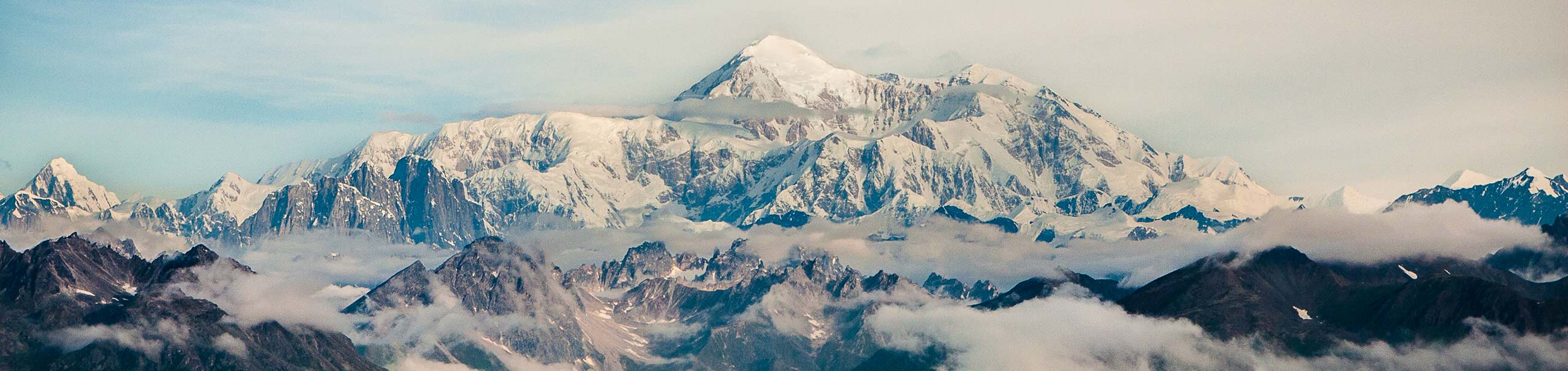
That's Mount Adams off in the distance. I took this photo near Panhandle Gap.


Mount Rainier at Reflection Lakes


This was our itinerary and permit to hike The Wonderland Trail.

Boulder Creek I think. If someone knows please correct me if I'm wrong!


Not a happy bird. It was early in the morning when I took this photo. I guess he couldn't find any worms.
